
DENVER TO SALT LAKE CITY: The direct route is over high terrain with very few service points. Better way to go Cheyenne. Remember that the high turbulence and high wind velocity effects increase during the day this region. Plan this flight, as well as most other describe hereafter, for early morning. Avoid all summer thunderheads in and around Salt Lake valley. Sometimes these procedure hailstorm which can cause serious damage to all-metal airplanes and which could be fatal to fabric-covered airplanes. During the winter months, smoke from factories in the Salt Lake valley are reduce visibility considerably, especially in the early morning hours.
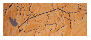
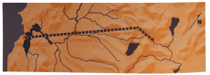
RENO TO SAN FRANCISCO: Follow the airway. It takes 8,000 to 9,000 feet to get over Donner Pass. in summer months thunderheads will build up over this area during the day, dissipating in the late afternoon. Terrific snowstorm, Freezing temperature, and high wind are encountered in winter months.
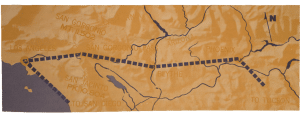
SALT LAKE CITY TO LOS ANGELES, BIA LAS VEGAS: Make about this later under “ Dessert” and : Cities and Industrial Areas,” but there are some mountains along the route which call for the usual care in mountain terrain flying. Stick to the airway between Salt Lake City and Las Vegas. Follow the highway west to las Vegas. If Mint Canyon is closed in. take and alternate route from Victorville through Cajon Pass via San Bernardino.
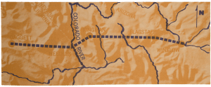
WINSLOW, ARIZ ., TO DAGGET, CALIF., VIA NEDDLE, CALIF.: This route is suggested only for planes with higher horsepower and long ragne, because of the distances involed, high altitude, winds, thunderstorm and snow. There is much snow between Winslow and Kingman during winter months. Gusty and high surface wind condition usually prevail during afternoon hours. There are usually stron westerly headwinds. Pilots should follow Highway 66 and take all the precautions advised for both mountain and desert flying.
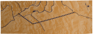
EL PASO TO PHOENIX, VIA TUCSON: This route suggest for the itinerant pilot whose trip would terminate in southern Ariona and California. The rages are lower, weather conditions are better, serbvice points more numerous, and generally good flying conditions prevail during early morning and late afternoon. Take mountain and desert precautions.
PHEONIX TO LOS ANGELES, VIA BLYTHE, CALIF: Here the flight had best be made in the early morning. In San Gornonio Pass, Flanked by San Jacinto peak (10,804 feet) and San Gornonio Mountain (11,502 feet), high winds and turbulence can become violent in the afternoon. The peaks make excelent landmarks, however. The same conditions prevail as on the Salt Lake- Las Vegas-Los Angeles flight.
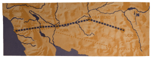
TUCSON TO SAN DIEGO: One suggested route is via Blythe and Los Angeles. A careful check of the coastal weather between Los Angeles and San Diego should be made before continuing on the last leg. Another suggested route via Gila Bend, Yuma, and El Centro since there are good airports along this route; it is shorter; and, according to some experienced pilots, it offers no more hazards than the Blythe-Los Angeles route. However, one word of caution on this latter route. Pilots are warned that it is good practice to stop at El Centro refuel, and make a thorough check of the weather ahead before going over the mountains to San Diego. The navy at one time required all trasient aircraft from the east to do this because many pilots, overflying El Centro, were getting lost or running out of fuel in the coastal fog or stratus clouds.
SAN DIEGO TO OREGON STATE LINE, VIA LOS ANGELES: Pilots will normally experience good flying conditions along the coastal area in both summer and winter. Coastal fog, prevailing between march and July, usually burn off by 10 a.m or noon, and there are occasional high fogs during winter months, suggesting a careful weather check. Smog may be encountered in the Los Angeles area (discussed in the time during the day most any time in the year. However, there are occasional thunderheads over these mountain in the summer and fairly heavy snow in the winter. Ideal flying conditions usually prevail in the San Joaquin-Sacramento Valley during summer and winter, with few low fogs in winter.
Experienced pilots who know the northern Rockies, the valley passes of the Cascades the Siskiyous, and the Bitter Roots give a general description of the outstanding topographic features of the Northwest States and explain the bearing this has on flying in general.
On the Western edge of Oregon and Washington there is an irregular, not too high, range of mountains known as the Coastal Range, topped to the north on the Olympic Peninsula by the very rugged and sparsely settles Olympic Mountain. There are between Puget Sound and Pacific Ocean just south of the Strait of Juan de Fuca. Through this Coastal Range between Oregon and Washington flows the mighty Columbia River. In southern Oregon this Coastal Range fused with the Cascade Mountains by Siskiyou Mountains.
East of the Coastal Range from Vancouver B.C., south along the edge of Puget Sound to Tacoma, Centralia, and Portland is a fairly wide valley known as Western Washington Valley, through which arterial highways and railroad sun. South of Portland to a little below Eugene is the Willamette Valley. These two Valley vary in elevation from practical sea level to approximately 400 feet, expect where the fringes of the Cascade Mountains project toward the west near Kelso Castle Rock, Washington, and just northwest of Portland where the Coastal Range project towards the Columbia River. South of Eugene to Medford and the east-west Siskiyou Mountains, the foothills of the Coastal Range and Cascade intermingle, which in some instances make for hazardous contact flying in bas weather.
East of the valleys mentioned above is the north and south range of mountains, rugged and sparsely settles for most of its distance, known as the Cascade Mountains. This range of mountains has many prominent high peaks. Just south of the Canadian border is Mt. Baker, 10,778 feet, and east and southeast of Mt. Baker are many mountain peaks that rise up to an elevation of more than 8,000 feet. One of these, Glacier Peak, has an elevation of 10,568 feet. South of Mt. Baker and Glacier Peak near Seattle is Mt. Rainier, 14,410 feet, and south of Mt. Rainier are Mt. St. Helens, 9,677 feet, and Mt. Adams 12,307 feet.
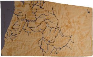
In Oregon south of the Columbia River, are Mt. Hood, Mt. Jefferson, and Three Sisters, all of which extend above 10,000 feet, and Mt. Thielsen and Mt. McLoughlin, both of which are above 9,000 feet in elevation. Through the Cascade Range of mountains are several passes that are used by railroads, highway, and flyways: Steven Pass, between Wenatchee and Everett; Snoqualmie Pass, east of Seattle to Yakima and Wenatchee; the gorge following the Columbia River; and the McKenzie Pass, east of Eugene. Some of this visual flight routes through mountain passes are depicted on Sectional Aeronautical Charts by a series of blue elongated diamonds. The Sectional Charts for the Northwest use to be unique in that they were the only ones having this depiction. However, other western charts now depict them and the charts for Alaska which will soon be published will also depict them.
East of the Cascades in Washington the Columbia River Basin extends eastward almost to the Washington – Idaho line. To a larger degree this area is a agricultural and flat open country. East of the Cascades in Oregon Land is much higher, with some mountainous areas extending northeast to the Wallowa and the Blue Mountains of eastern Oregon. In southeastern Oregon there is much sparsely settled, high, arid, desert-type land.
In northern Idaho and western Montana there are many mountain ranges running generally northwest-southeast that make up the great Rocky Mountain chain, and consist of some rugged terrain and sparsely settles areas. Through these chain of mountains there are few passes. The main pass follows the Coeur d’Alene, St Regis, and Clark Fork River Valleys and take you over Mullan Pass, Superior, and Missoula Valleys. In south central Idaho there are some very rugged mountains that branch off from the Bitter Root Range and cover a vast area. Included in the general “primitive” area are some desert and lava bed areas. In the Bitter Roots near Butte, Montana, and to the north is the Continental Divide. From the Divide eastward, the territory generally sweep into high plateaus except for scattered high mountains. such as those north of Yellowstone Park, southeast of Great Falls, and south of Billings where the Big Horn Mountains extend from Montana into Wyoming.
In southeastern Idaho the mountains are offshoots of more extensive mountains of western Wyoming, which include the Tetons and Wind River Range in Wyoming, and the Wasatch Mountains of northeastern Utah.
These mountains make for rather easy navigation, But the weather is strange there and the rugged and sparsely settled area make it necessary that the pilot be versed in more than just piloting ability. Knowledge of topography is very important.
The pilot flying in either summer or winter in this area must know the fundamentals of meteorology. The topography has a lot to do with the variable weather conditions.
There can be several types of weather prevalent in these regions at the same time say the experienced pilots. There can be valley of coastal fog west of the Cascade, even rain, and clear weather east of the Cascades, with a still different kind of weather in the mountains of Idaho and Montana. Many times during the summer in mountainous regions, particularly those of Montana and Idaho, there can be severe turbulence from thunderstorms often accompanied by hail, and it is not always possible to accurately forecast hail. Icing condition can be found either in summer and winter, and this is of special importance to any pilot.
The greatest problems for the inexperienced pilot in this Northwest Country are those associated with the weather, and the pilot must finally make his own decision. He should be willing to wait for improvement in conditions where he feels unsure, and must learn to turn back a little sooner than necessary if he encounters worse weather than anticipated enroute.
Experienced pilot warn against what they can fairly prevalent practice in this area of flying “on top”. This leads to numerous incidents and a few accident each year when pilots either become lost or are unable to get down VFR. Conditions should be carefully evaluated before venturing on top on this mountainous area for extend flight. Don’t permit yourself to get into situation where you run “fresh out of the experience”. Weather at destination can change quite rapidly or the tops can easily build to heights beyond the altitude performance of the aircraft or the pilot. Extended flights above 10,000 feet without the use of oxygen should be avoided. With the loss of an engine while flying on top, even a light twin-engine aircraft may be unable to maintain an altitude above the clouds and thus force the pilot into IFR conditions.
If and “on top” flight result in IFR flight, the regulations require that the pilots hold an instrument rating, meets the recent instrument flight experience requirements of FAR, Part 61, files and IFR flight plan prior to instrument flight in controlled airspace, and that the aircraft meets the equipment requirements of FAR, Part 91.
It may be well here to cover emergency procedures that can be used if you become lost. If you have a radio, don’t be bashful. Confess your predicament and call for help to anyone that will listen. Don’t wait too long. Your FAA Flight Service Stations are willing to help you. Search and Rescue facilities, including radar, radio, and DF (direction finding) stations are ready and willing to help. There is no penalty in asking for help. Stations with DF equipment may be able to receive you and give you a heading to follow to safety. Remember, the higher your altitude above the terrain the farther the operations range of your VHF radio.
If you have no radio, you may be able to alert civil or military radar system by flying the folloowing pattern: Fly a triangular pattern to the left. Hold each heading for 2 minutes. Make 120 degree turns at a rate of approximately one and one half degrees per second. Compete at least two such pattern before resuming original course. And then repeat at 20-minutes intervals. If observed by radar, a recue aircraft will be sent to your aid. Follow him and he will be able to lead you safety.
If you have an operating receiver but no transmitter, fly the same pattern to the right and listen for instructions on the appropriate emergency frequency (121.5 mHz. for VHF radios). The Idaho State Department of Aeronautics prints and distributes an aeronautical chart ont he back of which is a list of “Do’s and Don’ts” on mountains flying. Some have already been covered but we will list others to emphasize important points.
- First and foremost do not consider flying the back country unless you have at least one hundred fifty hours and are proficient in slow flight.
- Know your airplane. Do not take and airplane into this territory that will not take off and land in a minimum distance. It takes a lot of experience to handle a hot airplane inthis region.
- Remember that each thousand feet you are above sea level, it will increase your take off run approximately twenty-five percent, and your landing speed two percent with a longer landing roll due to your increase landing speed.
- Make your trips in early morning hours. The air, as a rule, begin to get around ten a.m., grows steadily worse until about four p.m., then gradually improves until dark.
- Stay out of the mountains if the wind is over twenty-five miles per hour.
- Keep your airplane as light as possible. Do not carry one pound of needless weight.
- Expect the wind to be changing constantly in the mountains. Don’t rely on cloud shadows for wind direction. If you cn’t gain altitude on one side of a canyon, try the other- if there is no improvement there, ride the center but under no circumstances head up any canyon or valley without sufficient altitude and room to turn around- the grade of the canyon may climb faster than your airplane.
- Remember you will not have a horizon to check the altitude of your plane once you begin to let down in the mountains. Check your airspeed and your altimeter.
- Use common sense on takeoffs. Remember none of these fields and long enough to land once again.
you have left the ground – let the airplane use all the runway it needs as long as runway is available. Do not pull it off until you are sure of flying speed.
Experience pilots believe strongly in advance study of your charts; in taking along sufficient gas to reach your destination or an acceptable and safe alternate; and in getting last minute advice.
Here is a list of eight flyways that are usually follow in this area:
- Salt Lake City to Pendleton, via Oregon, Malad City, Burley, Twin Falls, Boise, Baker, and LaGrande is originally a good flying route. You may want to take a lower altitude route; in this case, fly north from Oregon via Snowville, Strevell, and Malta. The area in southern Idaho can be very hot in summer, very cold in winter, and high winds often prevail. Check carefully on the weather over the Blue Mountains.
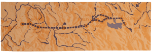
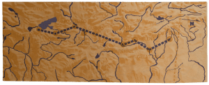
1.From Ogden through Great Falls to cut Bank, Montana, is one of the most difficult airways in the united States in the winter. There is more snow at Idaho Falls than any other airport in this area. High elevation mark this route from Ogden, Pocatello, Idaho Falls, Dubious, Whitehall, Butte, Helena, Great Falls, to Cut Bank. The airport at Butte is at, 5,554 feet elevation, and Monida pass is almost 7,000 feet. In hot weather it is possible for winds from 8 to 12 miles an hour to have peak guts up to 40 or 50 miles.
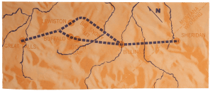
2.Froom Sheridan to Great Falls, vie Billings and Lewinston is a route with conditions similar to those already described. From Billings to Lewinston the airways go to the east of the Big Snowy Mountain. However, the easiest and lowest elevation is along route west of the Big Snowy through Judith Gap Bufallo. From Lewinston to Great Falls, generally follow the course of the railroad over not too rugged terrain, but at an altitude of about 4,200 feet.
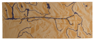
3.From Butte and Helena to the west, go via Deer Lodge, Garrison, Drummond, Superior, St. Regis, Mullan Pass, Kellogg, Coeur d’Alene, anf Spokane.
4.California to Oregon and Washington, via Red Bluff, California, into Klamath Falls or Medford, Oregon, depending on wether the destination is to be east or west of the Cascades. The most general route is Medford, Eugene, Portland, Tacoma, Seattle, and Bellingham. In winter, bad weather
often exist just south of the Oregon line over the Siskiyou Mountains and in the Willamette and West Washington Valleys. In most cases, the weather is better east of the Cascade.
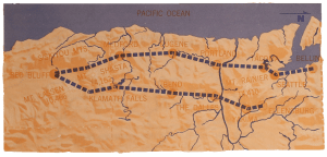
5.The route from Klamath Falls to Bend, Redmond, the Dalles, Yakima, and Ellensburg is generally open and flyable. In the summer the temperatures on this route cab get quite high. It is generally advisable to go north between Mt. Lassen and St. Shasta, with Shasta and the Cascades on the left. Always check the winds at these high altitudes, especially in the summer.
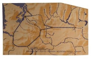
6.Spokane, Ephrata, Ellensburg, Easton, and Seattle is a route over fairly flat country and generally flyable. The mountain pass routes are depicted on this map as you will find them on sectional chart.
7.Between Ellensburg and Seattle there are many occasions when the weather east of the Cascades will be CAVU, with fog boiling over the Cascades and dissipating on their eastern slopes. Snoqualmie Pass on this route is at an altitude of about 3,500 feet, and on many occasions for from the west makes VFR flight impossible. You can get into trouble trying to fly over or under ths fog. Many pilots turn south from Ellensburg to Yakima and follow the Columbia River George into Portland and thence to Seattle. Or, when Snoqualmie is closed, Stevens and Stampede Passes might be used. In Oregon, pilots flying between Eugene and Redmond or Bend use the McKenzie River Pass. These last three named passes are not on the airways, and pilots should approach and fly through them with care and with sure knowledge of the weather.
Experienced pilots have a few words of caution for those who plan to fly the Columbia River Gorge route.
They tell us that the Columbia River Gorge route is only safe when the right weather conditions exist. Many pilots have become involved in accident while attempting flights through the gorge when ceiling and visibility were too low.
Numerous power lines cross the Columbia River. Some of them are quite high above the water. During low visibility conditions, particularly when there is precipitation, it is almost impossible to see those lines. Before a pilot attempts a flight through the gorge, he should know the location of these lines and how high they are above the river.
A large amount of traffic uses this flyway when other routes are closed. The gorge is very narrow in come areas which make it difficult to reverse course. Because of these narrow areas, it also becomes increasingly important for the pilot to remain alert for airplanes coming from the other direction.